Heavy rain likely in these parts of Gujarat during Navratri till 29th Sept
September 23, 2025
Surat: The latest forecast from the Indian Meteorological Department (IMD) brings unwelcome news for Garba enthusiasts, as it predicts more rainfall in parts of Gujarat. The forecast, valid until 29th September, has issued a yellow alert for heavy rains in certain areas over the next seven days.
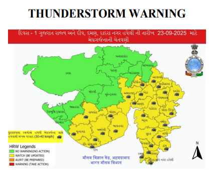
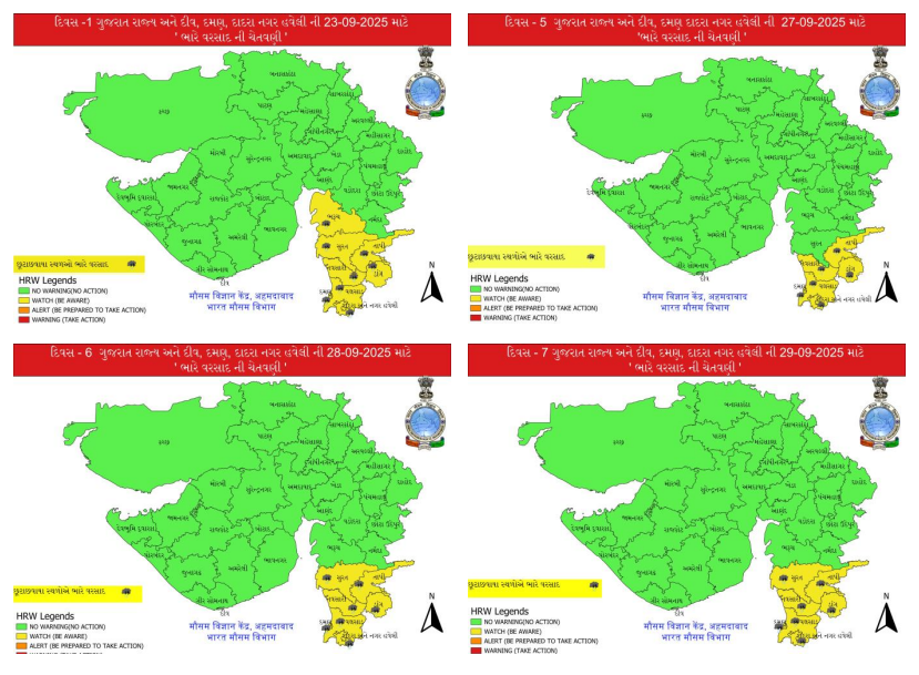
According to the bulletin, a yellow alert indicating the likelihood of heavy rain has been issued for Bharuch, Surat, Dang, Navsari, Valsad, Tapi, and in Daman, Dadra, and Nagar Haveli over the next 24 hours. Additionally, Gandhinagar, Aravalli, Kheda, Ahmedabad, Anand, Panchmahal, Dahod, Mahisagar, Vadodara, Chhota Udepur, Narmada, Rajkot, Junagadh, Amreli, Bhavnagar, Gir Somnath, Botad, and Diu might witness light thunderstorms with lightning and surface winds of 30–40 kmph, accompanied by light to moderate rain, and have been put on yellow warning till 8:30 AM tomorrow.
On 24th September, while heavy rain is not likely, light showers may occur across Gandhinagar, Aravalli, Kheda, Ahmedabad, Anand, Panchmahal, Dahod, Mahisagar, Vadodara, Chhota Udepur, Narmada, Bharuch, Surat, Tapi, Navsari, Valsad, Daman, Dadra and Nagar Haveli, Rajkot, Junagadh, Amreli, Bhavnagar, Gir Somnath, Botad, and Diu. Dry weather is expected in the remaining districts.
From 25th to 29th September, light rain is forecast for Anand, Panchmahal, Dahod, Vadodara, Chhota Udepur, Narmada, Bharuch, Surat, Tapi, Navsari, Valsad, Daman, Dadra and Nagar Haveli, Rajkot, Junagadh, Amreli, Bhavnagar, Gir Somnath, Botad, and Diu, while the rest of the state is expected to remain dry.
However, from 27th to 29th September, heavy rain is likely to return in parts of South Gujarat, and the IMD has issued a yellow warning for Surat, Tapi, Navsari, Dang, Valsad, Daman, and Dadra Nagar Haveli during this period.
Meanwhile, the withdrawal line of the southwest monsoon continues to pass through 32°N/74°E, Tarn Taran, Sangrur, Jind, Rewari, Tonk, Mahesana, Porbandar, and 21°N/68°E. Conditions are becoming favorable for further withdrawal of the southwest monsoon from additional parts of Gujarat and other states over the next 24 hours.
The IMD also stated that an upper-air cyclonic circulation lies over central Madhya Maharashtra and nearby areas at 3.1 km above mean sea level.
Furthermore, a low-pressure area is likely to form over northwest and adjoining central Bay of Bengal around 25th September. Moving nearly westwards, it is expected to become a depression over northwest and adjoining west-central Bay of Bengal off the South Odisha–North Andhra Pradesh coasts on 26th September. It is likely to cross the South Odisha–North Andhra Pradesh coasts around 27th September. DeshGujarat
Recent Stories
- India vs SL Match
- Free rides on AMTS buses for three days during Diwali
- 100 years of service to nation was our duty, so no celebration is needed: RSS Chief
- Commonwealth Sport Board Recommends Ahmedabad as Host City for 2030 Commonwealth Games
- Gujarat CM to visit Mumbai for listing of SMC's green municipal bonds on NSE